 Kapcsolat
 Hogyan vásároljunk
Kézbesítés
Vásárlási tanácsadó
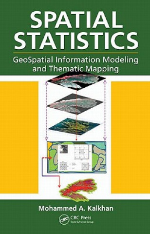
Spatial Statistics
 Angol
Angol
 380 b
380 b
30 nap a termék visszaküldésére
A vásárlók ilyet vásároltak


Geospatial information modeling and mapping has become an important tool for the investigation and management of natural resources at the landscape scale. Geostatistics reviews the types and applications of geospatial information data, such as remote sensing, GIS and GPS, as well as their integration into landscape scale geospatial statistical models and maps. Readers will learn the requirements and limitations of each geospatial tool. With statistical data analysis methods, the text includes laboratory exercises using ArcInfo, ArcGIS, ArcView, and other popular software for geospatial modeling. It also features case studies with examples.


Információ a könyvről
Angol

Ajándékozza oda ezt a könyvet még ma
Nagyon egyszerű
1 Tegye a kosárba könyvet, és válassza ki a kiszállítás ajándékként opciót 2 Rögtön küldjük Önnek az utalványt 3 A könyv megérkezik a megajándékozott címéreEzt is ajánljuk

 /
/
 Kemény kötésű
 65 713
Ft
65 713
Ft

 /
Puha kötésű
6 014
Ft
/
Puha kötésű
6 014
Ft


Szia! Libroamiko vagyok, a könyvtanácsadód.
Miben segíthetek?